
Thunder Bay, Ontario--(Newsfile Corp. - November 3, 2026) - Thunder Gold Corp. (TSXV: TGOL) (FSE: Z25) (OTCQB: TGOLF) ("Thunder Gold" or the "Company") is pleased to announce the following infill diamond drill results from the Company's flagship Tower Mountain Property, 40 kilometres west of Thunder Bay, Ontario.
Highlights:
- TM26-222 intersected 0.456 g/t Au over 451.5 metres from 60.0 metres;
- Gold mineralization starts at 60.0 metres and is continuous to 511.5 metres;
- Includes intervals of 0.880 g/t Au over 39.0 metres and 1.107 g/t Au over 28.5 metres;
- Estimated True Width equals 245.0 metres;
- Actual drilled grade of TM26-222 is within 2 milligrams of model predicted grade; and,
- Bench-3738-Ellen ("B-E") Trend remains open in all directions.
TM26-222 targeted Inferred resources located in the center of the Bench-3738-Ellen ("B-E") trend (Reference Figure 1.0). The southern contact was encountered 60.0 metres downhole. Gold mineralization was continuous to the northern contact which was intersected at a depth of 511.5 metres Reference Tables 2.0 and 3.0).
Wes Hanson, President and CEO states, "Since mid-August, drilling has focused on the B-E trend hosting the majority of the 2026 MRE Inferred resource (211.1 million tonnes averaging 0.45 g/t Au). To date, drilling has intersected 4.4 kilometres of semi-continuous gold mineralization, averaging 0.454 g/t Au from fourteen (14) holes nominally spaced on 100-metre centres. Drilling is confined within the current MRE optimized pit-shell to maximize resource conversion, but some of the holes have been extended beyond the currently defined pit limit, targeting the area immediately under the current optimized pit limit. These holes are intersecting longer, sustained intervals of higher-grade mineralization than the holes in the upper levels of the deposit. A total of 5,000 metres of drilling is planned prior to December 20th, and we fully expect results will continue to demonstrate minimal spatial and empirical variation to the current MRE model."
"Considering the correlation to date and the planned drilling to be completed, the Company has decided to reschedule the release date of the MRE update to February 2027. This allows the 5,000 metres of drilling planned for November and December to be included in the MRE update, maximizing the potential conversion of Inferred resource to the Indicated classification."
Table 1.0 provides the location and orientation of hole TM26-222.
Figure 1.0 is a plan view showing the location of TM26-222.
Table 2.0 summarizes the highlights of TM26-222 by relevant cut-off grades.
Table 1.0 – B-E Target – Drill Hole Location Bearing and Dip
| Hole ID | Easting | Northing | Elevation | Bearing | Dip | TD |
| TM26-222 | 300717 | 5377437 | 471 | 40 | -54.3 | 600 |
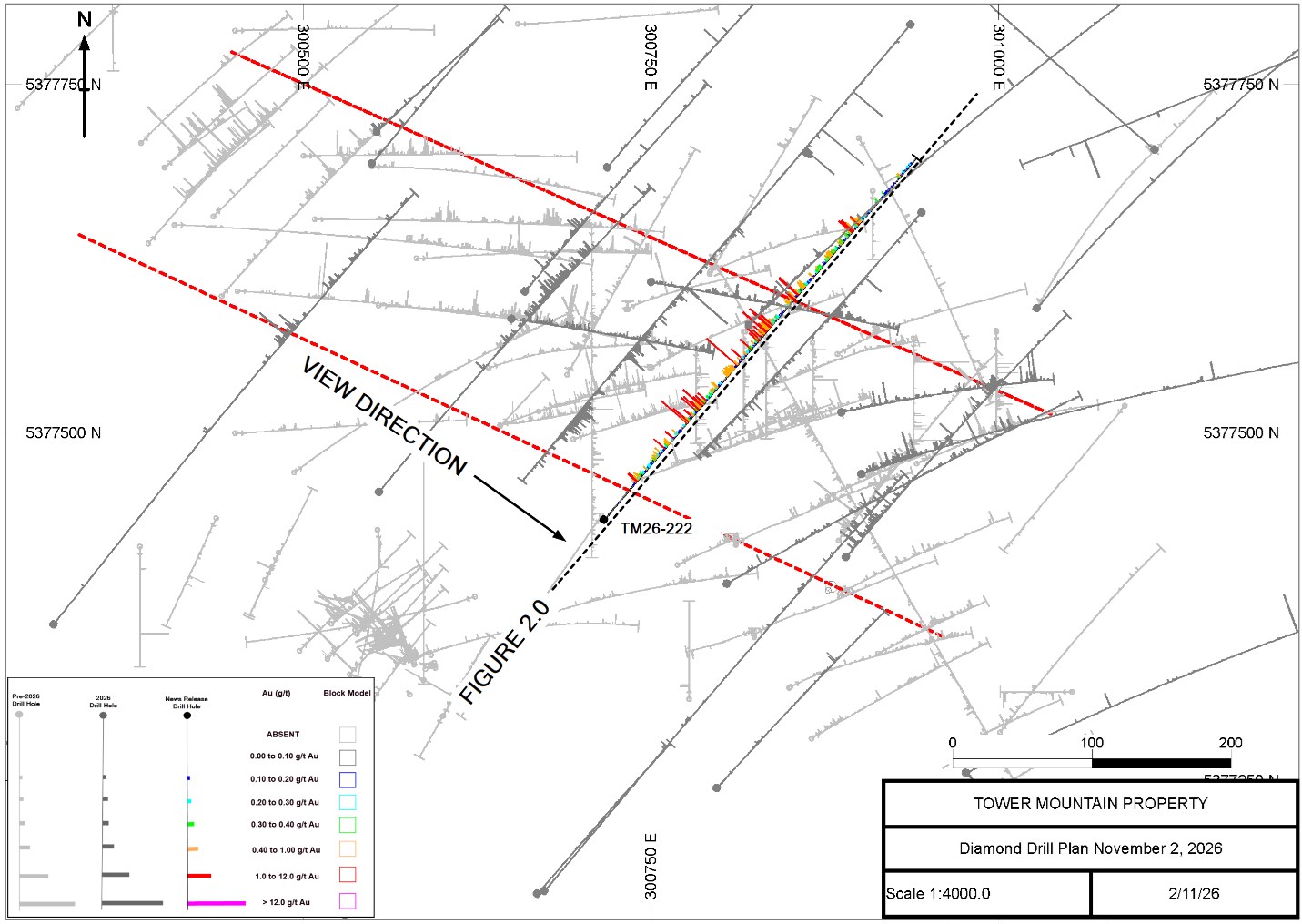
Figure 1.0 Bench Target Diamond Drill Plan – November 2, 2026
To view an enhanced version of this graphic, please visit:
https://images.newsfilecorp.com/files/5364/322125_d579bc3ac4dfaa2c_001full.jpg
TM26-222
TM26-222 (Figures 1.0 and 2.0) intersected both contacts of the B-E trend resulting in a true width of 245.0 metres averaging 0.456 g/t Au, commencing at a down hole depth of 60.0 metres (Reference Tables 2.0 and 3.0). Drilled from south to north, TM26-222 intersected the southern B-E contact within 10.0 metres of the interpreted southern contact. The northern contact was intersected approximately 100 metres north (beyond) the interpreted contact (Reference Figure 2.0).
Gold mineralization occurs in a variably brecciated and altered mix of volcanic tuffs and calc-alkalic intrusive rocks that are proportionately equal (50-50). Brecciation ranges from weak to intense. The breccias have been weakly to intensely altered by multiple, distinct, alteration assemblages.
Carbonate alteration is pervasive throughout the hole. Silicification is also ubiquitous. Hematite, chlorite, sericite and potassic alteration are patchy, typically observed over intervals of up to 50.0 metres in length.
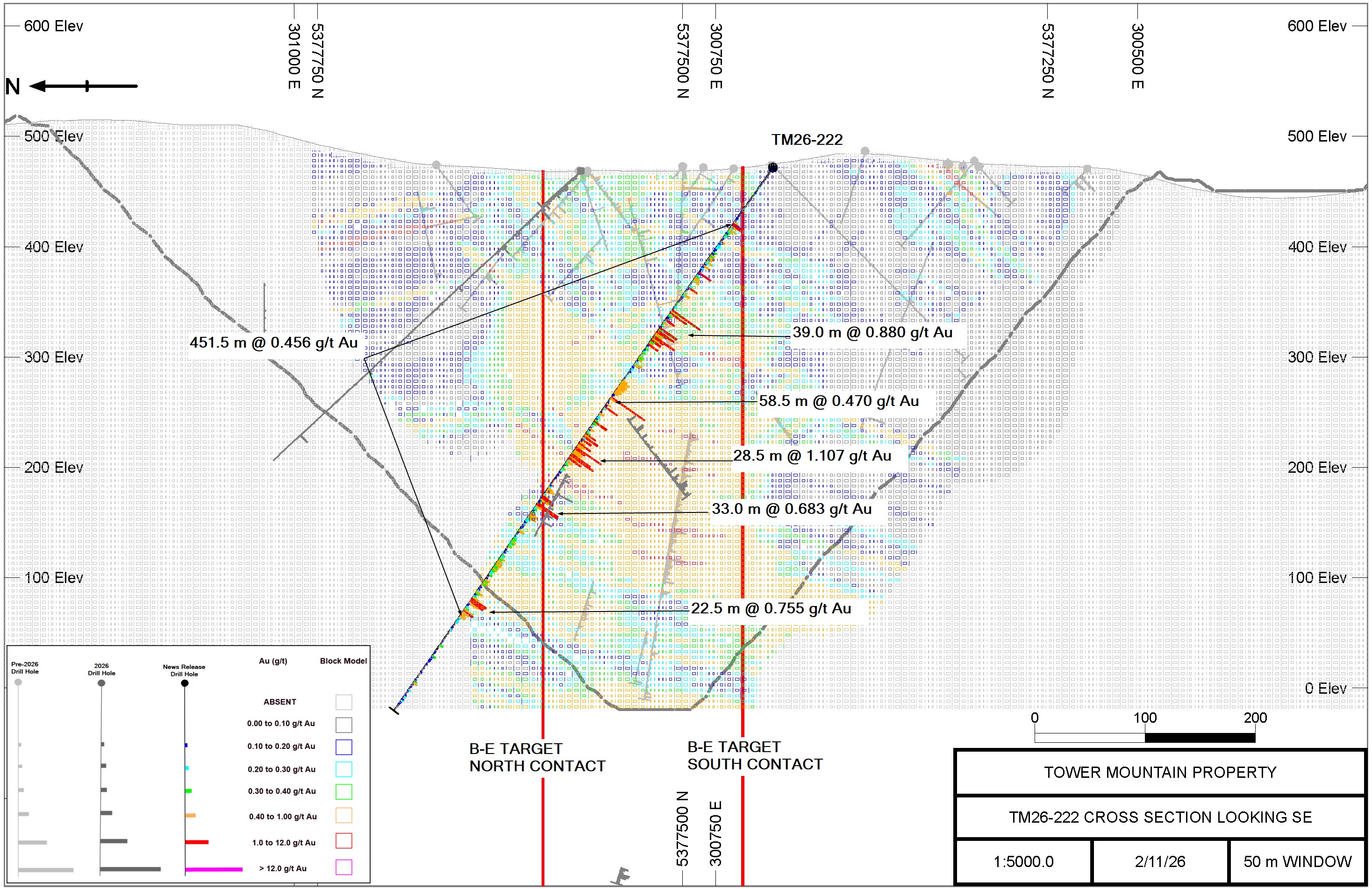
Figure 2.0 TM26-222 Cross Section Looking SE – November 2, 2026
To view an enhanced version of this graphic, please visit:
https://images.newsfilecorp.com/files/5364/322125_d579bc3ac4dfaa2c_002full.jpg
Table 2.0 – TM26-222 Significant Results
| Hole ID | From | To | Length | Grade | True Width |
| (m) | (m) | (m) | (Au g/t) | (m) | |
| TM26-222 | 4.7 | 60.0 | 55.3 | 0.052 | |
| and | 60.0 | 511.5 | 451.5 | 0.456 | 245.0 |
| includes | 60.0 | 126.0 | 66.0 | 0.395 | 35.8 |
| and | 126.0 | 157.5 | 31.5 | 0.187 | 17.1 |
| and | 157.5 | 196.5 | 39.0 | 0.880 | 21.2 |
| and | 196.5 | 223.5 | 27.0 | 0.289 | 14.7 |
| and | 223.5 | 235.5 | 12.0 | 0.085 | 6.5 |
| and | 235.5 | 294.0 | 58.5 | 0.470 | 31.7 |
| and | 294.0 | 322.5 | 28.5 | 1.107 | 15.5 |
| and | 322.5 | 354.0 | 31.5 | 0.175 | 17.1 |
| and | 354.0 | 387.0 | 33.0 | 0.683 | 17.9 |
| and | 387.0 | 474.0 | 87.0 | 0.277 | 47.2 |
| and | 474.0 | 496.5 | 22.5 | 0.755 | 12.2 |
| and | 496.5 | 600.0 | 103.5 | 0.124 | 56.2 |
True width is estimated where sufficient data allows. Where True Width is not estimated it is due to insufficient data.
Pyrite, closely associated with the gold mineralization, is persistent throughout the hole which is typical throughout the deposit. Pyrite content ranges from 0.5 to 5.0%.
Table 3.0 summarizes TM26-222 results at various cut-off grades from 0.0 g/t Au to 1.00 g/t Au. A minimum horizontal width of 6.0 metres (9.0-metre interval length) was used for both mineralized and non-mineralized interval selection.
Table 3.0 – TM26-222 Significant Results at Select Cut-off Grades
| Hole ID | Cut-off grade | From | To | Length | Grade | True Width |
| (m) | (m) | (m) | (Au g/t) | (m) | ||
| TM26-222 | 0.00 | 4.7 | 600.0 | 595.3 | 0.368 | 323.0 |
| includes | 0.10 | 55.5 | 226.5 | 171.0 | 0.438 | 92.8 |
| and | 235.5 | 511.5 | 276.0 | 0.472 | 149.8 | |
| and | 534.0 | 592.5 | 58.5 | 0.140 | 31.7 | |
| includes | 0.20 | 60.0 | 142.5 | 82.5 | 0.369 | 44.8 |
| and | 153.0 | 223.5 | 70.5 | 0.604 | 38.3 | |
| and | 235.5 | 336.0 | 100.5 | 0.625 | 54.5 | |
| and | 352.5 | 511.5 | 159.0 | 0.416 | 86.3 | |
| includes | 0.30 | 60.0 | 82.5 | 22.5 | 0.452 | 12.2 |
| and | 96.0 | 141.0 | 45.0 | 0.373 | 24.4 | |
| and | 157.5 | 219.0 | 61.5 | 0.673 | 33.4 | |
| and | 235.5 | 333.0 | 97.5 | 0.638 | 52.9 | |
| and | 354.0 | 388.5 | 34.5 | 0.667 | 18.7 | |
| and | 409.5 | 418.5 | 9.0 | 0.351 | 4.9 | |
| and | 427.5 | 496.5 | 69.0 | 0.473 | 37.4 | |
| includes | 0.40 | 60.0 | 70.5 | 10.5 | 0.681 | 5.7 |
| and | 96.0 | 141.0 | 45.0 | 0.373 | 24.4 | |
| and | 157.5 | 196.5 | 39.0 | 0.880 | 21.2 | |
| and | 208.5 | 219.0 | 10.5 | 0.427 | 5.7 | |
| and | 235.5 | 325.5 | 90.0 | 0.671 | 48.8 | |
| and | 354.0 | 387.0 | 33.0 | 0.683 | 17.9 | |
| and | 430.5 | 444.0 | 13.5 | 0.473 | 7.3 | |
| and | 468.0 | 496.5 | 28.5 | 0.675 | 15.5 | |
| includes | 0.50 | 61.5 | 70.5 | 9.0 | 0.726 | 4.9 |
| and | 157.5 | 196.5 | 39.0 | 0.880 | 21.2 | |
| and | 237.0 | 255.0 | 18.0 | 0.794 | 9.8 | |
| and | 280.5 | 325.5 | 45.0 | 0.848 | 24.4 | |
| and | 354.0 | 387.0 | 33.0 | 0.683 | 17.9 | |
| and | 430.5 | 439.5 | 9.0 | 0.510 | 4.9 | |
| and | 468.0 | 496.5 | 28.5 | 0.675 | 15.5 | |
| includes | 1.00 | 157.5 | 196.5 | 39.0 | 0.880 | 21.2 |
| and | 294.0 | 322.5 | 28.5 | 1.107 | 15.5 | |
| and | 363.0 | 373.5 | 10.5 | 1.150 | 5.7 |
True width is estimated where sufficient data allows. Where True Width is not estimated it is due to insufficient data. Minimum horizontal width of 6.0 metres (=9.0 metres interval length).
MRE Reconciliation
Reconciliation of drill results to date for the B-E Trend relative to the 2026 MRE model suggest an overall grade increase relative to model-predicted grades and there is no indication of bias. Figure 3.0 presents a summary of model-predicted grades compared to actual drilled grade for the fourteen (14) infill holes that post-date the 2026 MRE model.
The results, on a hole-by-hole basis, range from a low of -73% (TM26-219) to a high of 97% (TM26-210). This is typical and within expected tolerances. On a length-weight average basis, the comparison suggests that actual drilled grade of all fourteen (14) holes is currently 5% greater than the modeled grade of the 2026 MRE.
Similar results are observed for the project to date in the exploration drilling. (Reference Figure 4.0).
Mineralization intersected outside the 2026 MRE model limit, specifically, the high-grade results intersected in holes TM26-210 and TM23-137X that extend beyond the base of the 2026 MRE model, are not considered in the comparative analysis.
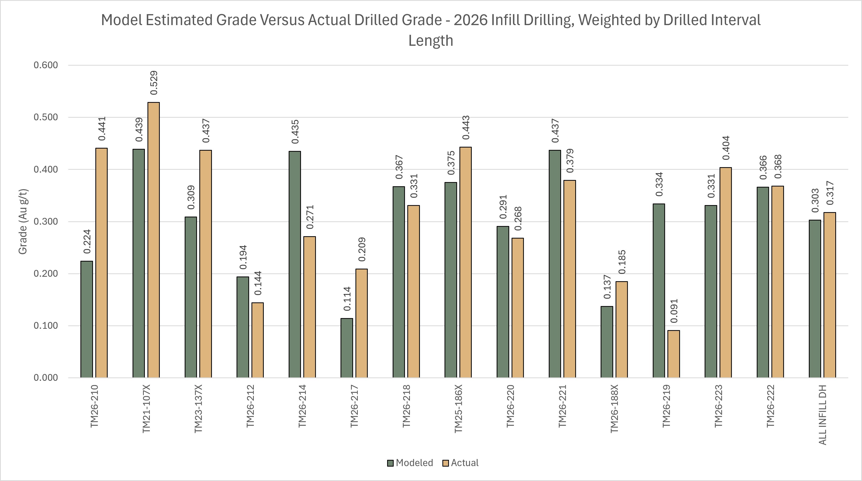
Figure 3.0 – Modelled Grade Versus Drilled Grade, Infill Drilling, 2026; Weighted by Interval Length
To view an enhanced version of this graphic, please visit:
https://images.newsfilecorp.com/files/5364/322125_d579bc3ac4dfaa2c_003full.jpg
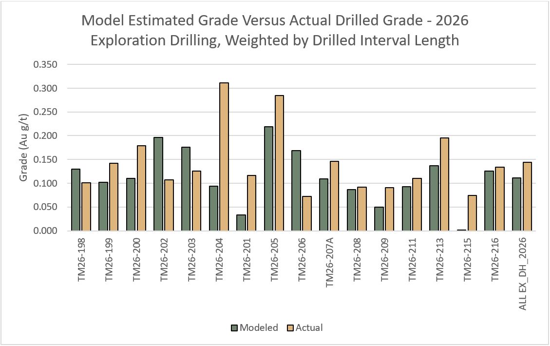
Figure 4.0 – Modelled Grade Versus Drilled Grade, Exploration Drilling, 2026; Weighted by Interval Length
To view an enhanced version of this graphic, please visit:
https://images.newsfilecorp.com/files/5364/322125_thundegold4.jpg
In an additional note, the Company will be granting 2.0M options at a $0.15 exercise price with a 24-month term to certain Directors and Contractors.
Quality Assurance and Quality Control
Diamond drilling utilizes NQ diameter tooling. The core is received at the on-site logging facility where it is photographed, logged for geotechnical, physical properties and geological data. Samples are identified, recorded, and cut in half by wet diamond saw. Half the core is sent for assay at an accredited laboratory with the remaining half core stored on site. A standard sample length of 1.5 meters is typically employed, varying only at major lithological contacts.
Certified standards and blanks are randomly inserted into the sample stream and constitute approximately 10% of the sample stream. Certified standards and blank performance is monitored with any failures evaluated and investigated to determine if said failure is a result of error during submission. Any unexplained failures are identified and the five samples preceding and following the failure are re-assayed. Commencing in 2026, duplicate pulps are prepared at a rate of 1 in every 20 samples. The duplicate pulps are sent to a second independent analytical facility for analyses.
Activation Laboratories Ltd., Thunder Bay, Ontario, ISO/IEC 17025:2017 is the primary independent analytical service provider.
AGAT Laboratories, Thunder Bay, Ontario, ISO/IEC 17025:2017 is the secondary, independent analytical facility.
Samples are, received, dried, crushed to 80% passing 2.0 mm. A 250-gram sample is split and pulverized. Samples are analyzed for gold using a 30-gram lead collection fire assay fusion (FA) with an atomic absorption (AAS) finish. All assay results greater than 5.0 g/t Au are re-assayed using a gravimetric analysis. All assays greater than 30.0 g/t Au are re-assayed using screen metallics where a representative 1000-gram sample is split sieved at 149µm. Assays are performed on the entire +149 µm fraction and two splits of the -149 µm fraction. A final assay is calculated based on the weight of each size fraction.
Qualified Person
Technical information in this news release has been reviewed and approved by Wes Hanson, P.Geo., President and CEO of Thunder Gold Corp., who is a Qualified Person under the definitions established by NI 43-101.
About the Tower Mountain Gold Property
The 7,625-hectare, 100%-owned Tower Mountain Property is beside the Trans-Canada highway, 40-km west of Thunder Bay, Ontario (pop. 120,000). Gold mineralization occurs in variably brecciated and altered rocks surrounding the calc-alkalic Tower Mountain Intrusive Complex ("TMIC"). Drilling to date has established an initial mineral resource parallel to the western contact of the intrusion representing approximately 25% of the TMIC halo.
The MRE has an effective date of January 19, 2026. A Technical Report titled "NI 43-101 Technical Report for the 2026 Mineral Resource Estimate on the Tower Mountain Project, Ontario, Canada." is available on the Company's website at www.thundergoldcorp.com and on SEDAR+ (www.sedarplus.ca) under the Company's Issuer profile.
The Report was prepared by Charley Murahwi, P.Geo., FAusIMM.; William Lewis, P.Geo., Tudorel Ciuculescu, P.Geo., and Richard Gowans, P.Eng., all of Micon International Limited ("Micon"), Toronto, Ontario, Canada. The Report was prepared in accordance with National Instrument 43-101 Standards of Disclosure for Mineral Projects ("NI 43-101") and CIM Definition Standards of Mineral Resources and Mineral Reserves.
The MRE is summarized as follows:
Tower Mountain Mineral Resource Estimate - January 19, 2026
| Category | Tonnage (Mt) | Grade (g/t Au) | Contained Metal ('000 oz gold) |
| Indicated | 34.5 | 0.46 | 514 |
| Inferred | 211.1 | 0.45 | 3,053 |
Notes:
- The effective date of this MRE is January 19, 2026.
- Messrs. William Lewis, P.Geo., Charley Murahwi, P.Geo., FAusIMM, and Tudorel Ciuculescu, P.Geo. from Micon International Limited are the Qualified Persons (QPs) responsible for this MRE.
- The MRE has been classified in the Indicated and Inferred categories. At this time, there are no Measured resources at the Tower Mountain Project.
- The calculated gold cut-off grade is 0.19 g/t Au.
- An average specific gravity (SG) value of 2.77 g/cm3 was used.
- The MRE used economic assumptions for open pit mining. The following economic parameters were used for generating the cut-off grade: a gold price of US$3,000/oz, 80% recovery, open pit mining cost of US$3.0/t, processing costs of US$8.0/t, general and administration cost of US$3.5/t, transportation cost of US$2.5/oz of gold, and a royalty of 3%.
- The open pit used slope angles of 30° in overburden and 50° in fresh rock.
- The block model is orthogonal and has a parent block size of 5 m x 5 m x 5 m, with minimum sub-block size of 2.5 m x 2.5 m x 2.5 m.
- The open pit optimization used a re-blocked size of 10 m x 10 m x 10 m.
- The mineral resources described above have been prepared in accordance with the current Canadian Institute of Mining, Metallurgy and Petroleum Standards and Practices.
- Numbers have been rounded to the nearest million tonnes and nearest thousand ounces. Differences may occur in totals due to rounding.
- Mineral Resources are not Mineral Reserves as they do not have demonstrated economic viability. The quantity and grade of reported Inferred Mineral Resources are uncertain in nature and there has been insufficient exploration; however, it is reasonably expected that a significant portion of Inferred Mineral Resources could be upgraded into Indicated Mineral Resources with further exploration.
- Micon QPs have not identified any legal, political, environmental, or other relevant factors that could materially affect the potential development of the mineral resources and of the estimate.
The remaining 75% of the TMIC halo demonstrates similar geology, alteration, and geophysical signatures and is untested by drilling.
A second gold trend, identified in 2026, outcrops at surface and is continuously mineralized over a 100-metre width. This gold mineralization occurs within Timiskaming-type conglomerates that have been traced for over 5.0 kilometres along a southwest trend paralleling the Thunder Lake Fault. The Company believes both targets offer opportunities to materially increase the total resource through systematic drilling.
About Thunder Gold Corp.
Thunder Gold is advancing the Tower Mountain project in Thunder Bay, Ont. -- an emerging gold system with the scale, consistency and quality to support a long-life, open-pit operation. Results from the disciplined drill programs have consistently reinforced confidence in the continuity and predictability of the discovery while highlighting significant potential for expansion across multiple zones of the Tower Mountain intrusive complex. With industry-leading drilling costs, existing infrastructure and a skilled local work force, Tower Mountain represents a rare combination of size, scalability and cost-effective growth.
At Thunder Gold, our vision is clear: to unlock a discovery that has the potential to become a transformational gold project, delivering long-term value for shareholders while contributing to the future of Canada's mining industry.
For more information about the Company please visit: www.thundergoldcorp.com.
On behalf of the Board of Directors,
Wes Hanson, P.Geo., President and CEO
For further information contact:
Wes Hanson, CEO
(647) 202-7686
whanson@thundergoldcorp.com
Bryan Baritot, Investor Relations
IR@thundergoldcorp.com
NEITHER THE TSXV NOR ITS REGULATION SERVICES PROVIDER (AS THAT TERM IS DEFINED IN THE POLICIES OF THE TSXV) ACCEPTS RESPONSIBILITY FOR THE ADEQUACY OR ACCURACY OF THIS RELEASE.
The information contained herein contains "forward-looking information" and "forward-looking statements" within the meaning of applicable securities legislation (collectively, "forward-looking statements"). Forward-looking statements relate to information that is based on assumptions of management, forecasts of future results, and estimates of amounts not yet determinable. All statements, other than statements of historical fact, are forward-looking statements and are based on predictions, expectations, beliefs, plans, projections, objectives and assumptions made as of the date of this news release, including the Company's plans regarding exploring its mineral exploration properties; anticipated results of geophysical surveys, drilling programs, geological interpretations and potential mineral recovery. Any statement that involves discussions with respect to predictions, expectations, beliefs, plans, projections, objectives, assumptions, future events or performance (often but not always using phrases such as "expects", or "does not expect", "is expected", "anticipates" or "does not anticipate", "plans", "budget", "scheduled", "forecasts", "estimates", "believes" or "intends" or variations of such words and phrases or stating that certain actions, events or results "may" or "could", "would", "might" or "will" be taken to occur or be achieved) are not statements of historical fact and may be forward-looking statements.
Forward-looking statements are subject to a variety of risks and uncertainties which could cause actual events or results to differ from those reflected in the forward-looking statements, including, without limitation: risks related to failure to obtain adequate funding on a timely basis and on acceptable terms; risks related to the outcome of legal proceedings; political and regulatory risks associated with mining and exploration; risks related to the maintenance of stock exchange listings; risks related to environmental regulation and liability; the potential for delays in exploration or development activities or the completion of feasibility studies; the uncertainty of profitability; risks and uncertainties relating to the interpretation of drill results, the geology, grade and continuity of mineral deposits; risks related to the inherent uncertainty of production and cost estimates and the potential for unexpected costs and expenses; results of prefeasibility and feasibility studies, and the possibility that future exploration, development or mining results will not be consistent with the Company's expectations; risks related to the gold price and other commodity price fluctuations; and other risks and uncertainties related to the Company's prospects, properties and business detailed elsewhere in the Company's disclosure record. Should one or more of these risks and uncertainties materialize, or should underlying assumptions prove incorrect, actual results may vary materially from those described in forward-looking statements. Investors are cautioned against attributing undue certainty or reliance on forward-looking statements. These forward-looking statements are made as of the date hereof and the Company does not assume any obligation to update or revise any forward-looking statements, other than as required by applicable law, to reflect new information, events or circumstances, or changes in management's estimates, projections or opinions. Actual events or results could differ materially from those anticipated in the forward-looking statements or from the Company's expectations or projections.

To view the source version of this press release, please visit https://www.newsfilecorp.com/release/322125